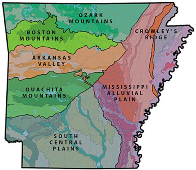
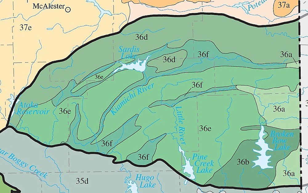
Ecoregion
36 Information. Ouachita Mountains (Arkansas & Oklahoma)
Arkansas Information:
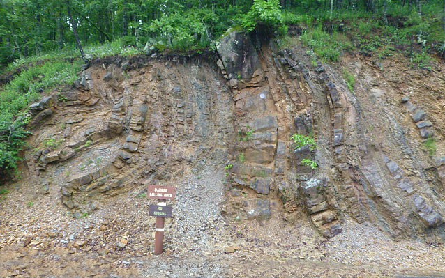
The Ouachitas are made up of ridges, hills, and valleys formed by the erosion of folded and faulted Paleozoic
sandstone, shale, and chert, known locally as novaculite. They are a continuation of the Appalachians,
formed during the late Paleozoic Era when an ocean closed and continents collided, causing marine sediments to be folded,
faulted, and thrust northward. The Ouachitas are structurally different from the Boston Mountains (38),
more folded and rugged than the lithologically distinct Ozark Highlands (39), and physiographically unlike the Arkansas Valley
(37), South Central Plains (35), and Mississippi Alluvial Plain (73).
Potential natural vegetation is oak–hickory–pine forest;
it contrasts with the oak–hickory forest that dominates Ecoregion 39 and the northern part of Ecoregion 38. Today, loblolly
pine and shortleaf pine grow in a distinctive mix of thermic Ultisols and Inceptisols. Logging and recreation are major land
uses, and pastureland and hayland are found in broader valleys.
Regional water quality is influenced by lithology, soil composition, and land
use activities. In most reaches, water quality is exceptional; typically, total phosphorus, turbidity,
total suspended solids, and biological oxygen demand values are lower whereas dissolved oxygen levels are higher than in Ecoregions
35, 37, and 73. Water hardness varies by level IV ecoregion; Ecoregions 36d and 36e tend to have the lowest
hardness values while progressively higher values occur in Ecoregions 36a, 36b, and 36c. Stream substrates
are made up of gravel, cobbles, boulders, or bedrock; they contrast with the fine-grained substrates of lower gradient streams
in Ecoregions 35 and 73. The fish community is dominated by sensitive species; minnows and sunfish along
with darters and bass are common.
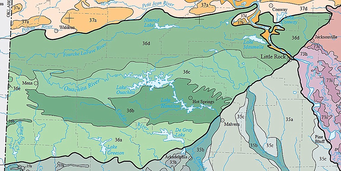
36a: The low ridges and hills of the Athens Plateau are
widely underlain by shale in contrast to other parts of Ecoregion 36. Rocks are less resistant to erosion
than in higher, more rugged Ecoregions 36b, 36d, and 36e but are more resistant than the unconsolidated rocks of the coastal
plain in Ecoregion 35.
Today, pine plantations are
widespread; they are far more extensive than in the more rugged parts of Ecoregion 36 in Arkansas. Pastureland
and hayland also occur. Cattle and broiler chickens are important farm products.
Water quality values are distinct from Ecoregion 36c.
36b:
The Central Mountain Ranges are dominated by east-west trending ridges that are characteristically steep
and rugged and underlain by resistant sandstone and novaculite (chert). Igneous intrusions occur along
with associated hot springs. Rock outcrops, and shallow, stony soils are widespread. Novaculite
glades occur.
Potential natural vegetation
is oak–hickory–pine forest. Perennial springs and seeps are common and support diverse vegetation.
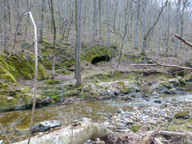
Constricted valleys between ridges have waterfalls and rapids. The surface waters of Ecoregion 36b have
very low nutrient, mineral, and biochemical water quality parameter concentrations and turbidity.
Logging is not nearly as common as in the less rugged Athens Plateau (36a).
36c: The Central Hills, Ridges, and Valleys ecoregion is lower, less rugged, and more open
than neighboring Ecoregions 36b and 36d. Ecoregion 36c is underlain by folded and faulted sandstone, shale, and novaculite
(chert); the lithologic mosaic is distinct from the Athens Plateau (36a).
Its forests are codominated by loblolly pine–shortleaf pine and upland oak–hickory–pine forest types.
Pastureland is also common, much more so than in Ecoregions 36b and 36d.
36d:
The Fourche Mountains are the archetypal Ouachita Mountains. Ecoregion 36d is composed
of long, east-west trending, forested ridges composed of sandstone. Intervening valleys are cut into shale.
Ridges are longer, habitat continuity is greater, the lithologic mosaic is different, and the topographic orientation is more
consistent than in other parts of the Ouachita Mountains (36).
Differences in moisture and temperature between north- and south-facing slopes significantly influence
native plant communities; they are products of the prevailing topographic trend. Forests on steep, north-facing
slopes are more mesic than on southern aspects; grassy woodlands are found on steepest, south-facing slopes.
Pastureland and hayland are restricted to a few broad valleys. Logging is not nearly
as intensive as in the commercial pine plantations of the less rugged Athens Plateau (36a).
Nutrient, mineral, and biochemical water quality parameter concentrations are low in
the surface waters of Ecoregion 36d but turbidity can be higher than in other mountainous parts of the Ouachitas.
36e: The Western Ouachitas ecoregion is composed of mountains, hills, and narrow valleys. In
Arkansas, Ecoregion 36e is confined to Round Mountain in western Polk County, where it is underlain by sandstone and shale;
novaculite (chert) is absent in contrast to the Central Mountain Ranges (36b). Ridge top elevations exceed
2,300 feet in Arkansas; both elevation and precipitation decrease westward into Oklahoma. Ecoregion 36e
in Arkansas is higher and more rugged than the lithologically distinct Athens Plateau (36a).
Today, pine and upland oak–hickory–pine forest types codominate. Ecoregion
36e in Arkansas and Oklahoma contains, perhaps, the greatest concentration of critically-imperiled and imperiled species in
mid-North America.
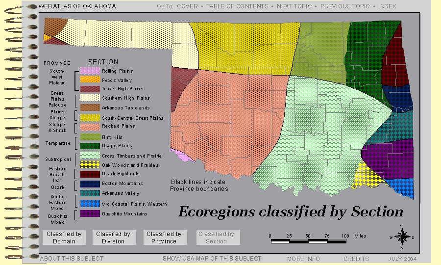
Oklahoma Information:
The forested low mountains of Ecoregion 36 are characteristically underlain by folded, sedimentary rocks of Paleozoic
age. In Oklahoma, mean annual rainfall in this humid ecoregion is 43 to 57 inches. Oak–hickory–shortleaf
pine forest is native on uplands; it contrasts with the oak–hickory forest of Ecoregions 38 and 39 and the oak savanna or prairie
of drier ecoregions to the west.
Ecoregion
36 remains mostly forested, but pastureland and hayland occur in wider valleys. Logging and recreation
are major
land uses.
Most streams have gravel,
cobble, boulder, or bedrock substrates but a few have sandy bottoms. Stream gradients are steeper than
in Ecoregion 35. Turbidity, total phosphorus, total suspended solids, and biological oxygen demand values are lower, and dissolved
oxygen levels are higher, than in the streams of Ecoregions 35 and 37.
Common fishes include the longear and green sunfishes, yellow bullhead, brook silverside, blackstripe and blackspotted topminnows,
largemouth
bass,
smallmouth bass, redfin darter, suckers, and the bigeye, Ouachita Mountain, and ribbon shiners. Orangebelly
darters, grass pickerels, and tadpole madtoms are also found in Ecoregion 36, but are absent from Ecoregions 38, 39, and 40.
36f: The broad Western Ouachita Valleys are etched into Mississippian Stanley Shale and veneered
with terrace, alluvial, and colluvial deposits.
Ecoregion 36f includes the Kiamichi River, one of the few tributaries to the Red River that has not been heavily impacted
by water diversion or major land use changes. The Kiamichi River system is home to more than half of Oklahoma’s
mussel species, including eight imperiled or vulnerable species.
Natural vegetation is oak–hickory–pine forest on uplands and bottomland forest on floodplains
and low terraces. Prairies occurred in Ecoregion 36f prior to the 20th century, but were lacking from the
other, more mountainous parts of Ecoregion 36. Today, pastureland, woodland, and hayland are common; poultry, cattle,
and hogs are the main farm products.
Sources:
Ecoregions of Arkansas. U.S. EPA. ftp://ftp.epa.gov/wed/ecoregions/ar/ar_front.pdf.
Ecoregions of Oklahoma. U.S.
EPA. ftp://ftp.epa.gov/wed/ecoregions/ok/ok_front.pdf.